-40%
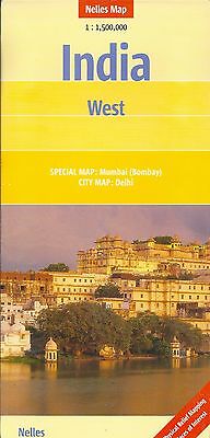
Map of India, West, by Nelles Map
$ 2.08
- Description
- Size Guide
Description
Map of India, West, by Nelles MapWestern India at 1:1,500,000 in a series of double-sided maps from Nelles with their slightly smaller size offering a convenient format for use when travelling. Coverage extends from well north of Delhi to Mumbai/Bombay and includes Jaipur, Agra and Ahmadabad. The map also provides a street plan of central districts of Delhi, plus an enlargement showing in greater detail the environs of Mumbai.
Maps in the Nelles regional series of India present the country’s road and rail networks on a base with relief shading to show the topography. National parks and nature or game reserves are highlighted, as are numerous places of interest. Also shown are the country’s internal administrative boundaries with names of the states. Each map includes enlargements for most visited areas and/or street plans of main cities. Latitude and longitude are shown by margin ticks at 2°. None of the maps are indexed. Map legend includes English.
Includes:
Special Map - Mumbay (Bombay) (1:300.000)
City Map - Delhi (1:50.000)
Two-sided map
Legend Key in three languages
When unfolded, map measures approx. 30" x 20"
Note: Map is new, but shows minor shop wear on cover.
Map retails for $ 10.95, publication date: 2006, ISBN
978-3865740403
